CEN 302 Canadian Sailing Directions. Lake Ontario/Канадские лоции. Озеро Онтарио
Книга на английском языке
The First Edition of Sailing Directions, CEN 302 - Lake Ontario, 1996, has been compiled from Canadian Government and other information sources. In general, all hydrographic terms used in this booklet are in accordance with the meanings given in the Hydrographic Dictionary (Special Publication No. 32), published by the International Hydrographic Bureau.
This edition introduces a new presentation and layout of the geographical areas.
General information for the Great Lakes is grouped in one booklet: Sailing Directions, CEN 300 - General Information, Great Lakes . It contains navigational information and a brief description of the main port facilities as well as geographic, oceanographic and atmospheric characteristics. A geographical index at the end of that booklet should also be consulted.
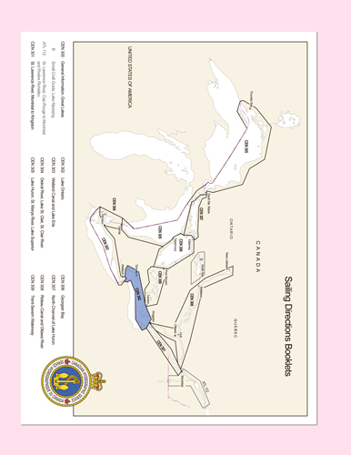
The detailed descriptions of the geographical areas is given in a series of volumes and booklets. Their limits are printed on the back cover of the booklets. The appropriate descriptive booklet(s) should be consulted in conjunction with CEN 300 - General Information, Great Lakes booklet.
Tidal, water level and current information has been revised by the Tides, Currents and Water Level Section of the Canadian Hydrographic Service.
Meteorological and ice information has been revised by the Atmospheric Environment Service, Department of the Environment.
The photographs are by the Canadian Hydrographic Service, Fisheries and Oceans Canada.
Contents
Preface
Explanatory notes
Abbreviations
Chapter 1 Everett Point to Murray Canal - Inner Route General
Limits. Limiting depths. Overhead clearances. Aids to navigation. Ice. Magnetic disturbances
Kingston to Upper Gap
Everett Point to Brother Island
North Channel
NW coast of Amherst Island. NW coast of North Channel
Bay of Quinte
Adolphus Reach
Approaches to Picton Bay and Long Reach
Picton Bay. Long Reach
Deseronto to Belleville
Telegraph Narrows. Telegraph Narrows to Big Bay. Big Bay to Belle
Belleville
Belleville to Trenton
Norris-Whitney Skyway Bridge to The Narrows. The Narrows to Tret
Trent-Severn Waterway. The Narrows to Murray Canal. Murray Ca
Chapter 2 Wolfe Island to Presqu’ile Point - Outer route
General
Limits. Caution. Wolfe Island. Bear Point. Ship Routing
Lake Ontario - United States shore
Lake Ontario - Canadian shore
Wolfe Island to Long Point. Islands and offshore dangers SW of Wolfe Island. Wolfe Island to Amherst Island. Amherst Island. Dangers SE and south of Amherst Island. Upper Gap. Prince Edward Bay. Long Point
Long Point to Presqu’ile Point
Long Point to Point Petre. Point Petre to Scotch Bonnet Island. Islands and dangers off Huycks Point. Scotch Bonnet Island to Presqu’ile Point. Approaches to Wellers Bay and Presqu’ile Bay. Wellers Bay. Presqu’ile Bay. SW approach to Murray Canal
Chapter 3 Presqu’ile Point to Toronto
General
Limits
Presqu’ile to Cobourg
Cobourg to Newcastle
Newcastle to Oshawa
Oshawa to Frenchman’s Bay
Frenchmen’s Bay to Toronto
Toronto
Chapter 4 Toronto to Hamilton
General
Limits
Toronto to Port Credit
Humber Bay. Mimico to Port Credit
Port Credit to Oakville
Oakville to Bronte
Bronte to Burlington Canal
Burlington Canal
Hamilton Harbour
Chapter 5 Hamilton to Niagara River
General
Limits. Caution
Hamilton to Fifty Point
Fifty Point to Jordan Harbour
Jordan Harbour to Port Dalhousie
Port Dalhousie to Port Weller
Port Weller
Port Weller to Niagara River
Lower Niagara River
Appendices Sail Plan
Distance Tables
Index


