ARC 400 Canadian Sailing Directions. General Information, Northern Canada/–ö–į–Ĺ–į–ī—Ā–ļ–ł–Ķ –Ľ–ĺ—Ü–ł–ł. –ě–Ī—Č–į—Ź –ł–Ĺ—Ą–ĺ—Ä–ľ–į—Ü–ł—Ź, –°–Ķ–≤–Ķ—Ä–Ĺ–į—Ź –ö–į–Ĺ–į–ī–į
–ö–Ĺ–ł–≥–į –Ĺ–į –į–Ĺ–≥–Ľ–ł–Ļ—Ā–ļ–ĺ–ľ —Ź–∑—č–ļ–Ķ
The First Edition of Sailing Directions, ARC 400 - General Information, Northern Canada, 2009, has been fully updated from Canadian Government and other information sources.
In general, all hydrographic terms used in this booklet are in accordance with the mean-Ings given in the Hydrographic Dictionary (Special Publication No. 32), published by the International Hydrographic Bureau.
This booklet contains navigational information and a brief description of the main port facilities as well as geographic, oceanographic and atmospheric characteristics.
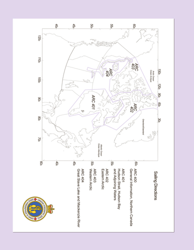
Detailed descriptions of geographical areas of Northern Canada are given in ARC 401 , Arctic Canada Vol. II (ARC 402 ), Arctic Canada Vol. 3 (ARC 403 ), and Great Slave Lake and Mackenzie River (ARC 404 ).
Their limits are printed on the back cover. The appropriate descriptive booklet(s) of Sailing Directions should be consulted in conjunction with ARC 400 - General Information, Northern Canada, which provides additional information.
Tide, water level and current information has been revised by the Canadian Hydrographic Service.
Photographs are supplied by the Canadian Hydrographic Service and the Canadian Coast Guard, Fisheries and Oceans Canada. Photographs by individuals are acknowledged where they occur in the booklets.
Contents
Preface
Explanatory notes
Abbreviations
Chapter 1 Navigational Information General
Routes
Hudson Strait
Northwest Passage
Arctic Ocean
Shipping routes
Distances
Arctic Canada Traffic System (NORDREG)
Pilotage
Hazards
Climate induced
Magnetics
Refraction
Cables and pipelines
Oil and gas exploration
Mandatory nautical publications
International Maritime Organization (IMO) publications
Canadian Hydrographic Service (CHS) publications
Canadian Coast Guard (CCG) publications
Optional nautical publications
Use of charts
CHS Charts
Corrections to charts
Reliance on a chart
North American Datum 1983 (NAD83)
Chart datum
Tides and tidal streams
Sailing Directions
Aids to Navigation
Buoys
Buoyage
Fixed aids
Radio
Radio medical advice
Radio distress communications
Ionospheric disturbances
Communications procedures
Radio Aids to Navigation
Radiobeacons
Radar
NAVSTAR Global Positioning System (GPS)
Automatic Identification Systems
Canadian Coast Guard
Search and Rescue
Aircraft signals
Cold water survival
Regulations
Chapter 2 Geographical Information
General
Northwest Territories
Yukon
Nunavut
Inuit
A culture rooted in the land
The contact period
The Inuit economy today
Plant and Animal Life
Vegetation
Fish
Marine mammals
Small land mammals
Fur bearers
Large mammals
Birds
Insects
Reptiles and amphibians
Chapter 3 Physiography
General
Hudson Bay area
Arctic Eastern block
Arctic Western block
Arctic Northern block
Great Slave Lake - Mackenzie River area
Chapter 4 Natural Conditions
General
Submarine Topography
Hudson Bay area
Arctic Archipelago
Beaufort Sea - Pingos
Athabasca - Mackenzie waterway
Tides
Hudson Bay area
Arctic Archipelago
Tidal streams and currents
Hudson Strait
Hudson Bay
Arctic Archipelago
Climate of the Canadian Arctic
Climate controls
Seasons
Winds
Air temperature
Clouds and precipitation
Visibility and fog
Ice Regime, Hudson Bay area
Hudson Strait and Ungava Bay
Hudson Bay
James Bay
Foxe Basin


