PAC 201 Canadian Sailing Directions. Juan de Fuca Strait and Strait of Georgia/Канадские лоции. Пролив Хуан-де-Фука и пролив Джорджия
Книга на англйском языке
The First Edition of Sailing Directions, PAC 201 - Juan de Fuca Strait and Strait of Georgia, 2012, has been compiled from Canadian Government and other information sources. All hydrographic terms used in this booklet are in accordance with the meanings given in the Hydrographic Dictionary (Special Publication No. 32), published by the International Hydrographic Bureau.
General information for the Pacific Coast is grouped within one booklet, Sailing Directions, PAC 200 - General Information, Pacific Coast , 2006. It contains navigational information and a brief description of the main port facilities as well as geographic, oceanographic and atmospheric characteristics.
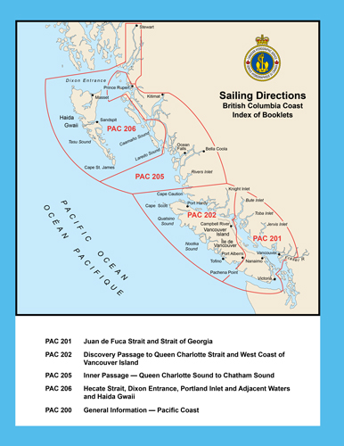
The detailed description of the geographical areas is given in a series of volumes and booklets. Their limits are printed on the back cover of each booklet. The appropriate descriptive booklet(s) should be consulted in conjunction with the PAC 200 - General Information booklet.
The photographs are by TRG Graphics, Brentwood Bay, B.C.
Contents
Preface
Explanatory notes
Abbreviations
Chapter 1 Juan de Fuca Strait - Pachena Point to Royal Roads
General
Juan de Fuca Strait and Approaches
Juan de Fuca Strait - South Approach
Juan de Fuca Strait - South Side
Juan de Fuca Strait - North Approach
Juan de Fuca Strait - North Side
Sooke Harbour and Approach
Becher Bay and Approach
Race Rocks
Race Rocks to Royal Roads
Chapter 2 Esquimalt Harbour and Victoria Harbour
General
Esquimalt Harbour and Approach
Victoria Harbour and Approach
Victoria Harbour to Discovery Island
Chapter 3 Brotchie Ledge to Vancouver - Haro Strait, Boundary Pass and SE Strait of Georgia
General
Haro Strait and Boundary Pass
Haro Strait - South Approach
Haro Strait - South End
Haro Strait - North End
Boundary Pass - North Side
Boundary Pass - South Side
Boundary Pass - East End
Strait of Georgia - SE Part
Boundary Bay - Semiahmoo Bay
Point Roberts to Point Grey
Chapter 4 Fraser River, Pitt River and Lake, Harrison River and Lake
General
Fraser River Main Channel
Sand Heads to Steveston
Steveston to Tilbury Island
Annacis Island to New Westminster
New Westminster - Fraser Port
Fraser River Secondary Channels
Fraser River - North Arm
Fraser River - Middle Arm
Canoe Passage
Sea Reach and Ladner Reach
Annacis Channel
New Westminster to Douglas Island
Pitt River
Pitt Lake
Douglas Island to Cresent Island
Cresent Island to Harrison River
Harrison River
Harrison Lake
chapter 5 Vancouver Harbour and Howe Sound
General
Approach to Vancouver Harbour
Vancouver Harbour - General
First Narrows
Vancouver Harbour - Western Portion
Second Narrows
Vancouver Harbour - Central and Eastern Portions
Indian Arm
False Creek
Howe Sound - General
Queen Charlotte Channel
Queen Charlotte Channel - East Side
Queen Charlotte Channel - West Side
Ramillies and Montague Channels
Squamish Harbour
Collingwood Channel
Barfleur Passage
Gibsons and Approaches - Shoal Channel
Gambier Island - South Side
Thornbrough Channel
Chapter 6 Gulf Islands South - Oak Bay to Ladysmith Harbour
General
Oak Bay and Approaches
Cordova Channel
Sidney Channel
Sidney and Tsehum Harbour
Miners Channel and Prevost Passage
Moresby and Shute Passages
Tsehum Harbour to Colburne Passage
Colburne Passage
Stranger and Gosse Passages
Satellite Channel
Fulford Harbour and Approaches
Cowichan Bay
Saanich Inlet
Swanson Channel
Bedwell Harbour, Pender Canal and Port Browning
Bedwell Harbour
Pender Canal
Port Browning
Plumper Sound and Navy Channel
Plumper Sound
Navy Channel
Lyall Harbour
Winter Cove, Georgeson Passage and Approach
Tumbo Channel to Active Pass
Active Pass
West Approach to Active Pass
Helen Point to Georgina Point
Captain Passage
Ganges Harbour and Approach
Trincomali Channel
Clam Bay and Approach
Porlier Pass
Houstoun Passage
East Coast Galiano Island and Valdes Island
Sansum Narrows
Stuart Channel
Osborn Bay (Crofton) and Approach
Osborne Bay to Chemainus Bay
Chemainus Bay and Approach
Ladysmith Harbour and Approach
Telegraph and Preedy Harbours
Chapter 7 Gulf Islands North - Thetis Island to Nanaimo Harbour
General
Thetis Island to Dodd Narrows
Dodd Narrows
Northumberland Channel
Pylades Channel
False Narrows
Gabriola Passage
Silva Bay and Approaches
Nanaimo Harbour and Approach
Nanaimo Harbour
Nanaimo Harbour - Inner Portion
Departure Bay
Chapter 8 Strait of Georgia - NW Portion
General
Strait of Georgia - NW Portion
Nanoose Harbour and Approaches
Ballenas Channel
Ballenas Channel to Baynes Sound
Baynes Sound
Lambert Channel and Hornby Island
Comox Harbour and Approach
Lasqueti Island
Sabine Channel
Texada Island - West Coast
Cape Lazo to Cape Mudge
Chapter 9 Sunshine Coast
General
Howe Sound to Sargeant Bay
Welcome Passage
Halfmoon Bay
Buccaneer Bay
Smuggler Cove
Secret Cove
Malaspina Strait
Texada Island - East Coast
Secret Cove to Black Point
Pender Harbour and Approaches
Approach to Agamemnon Channel
Malaspina Strait - NE Portion to Albion Point
Agamemnon Channel
Malaspina Strait - NW Portion
Sturt Bay and Van Anda Cove
Jervis Inlet and Approaches
Hardy Island to Captain Island
Hotham Sound
Prince of Wales Reach
Princess Royal and Queens Reaches
Malibu Rapids and Princess Louisa Inlet
Sechelt Inlet and Approaches
Skookumchuck Narrows
Skookum Island to Porpoise Bay
Narrows Inlet
Salmon Inlet
Algerine and Shearwater Passages
Powell River and Westview
Powell River to Sarah Point
Manson Passage
Baker Passage
Malaspina and Adjacent Inlets
Chapter 10 Desolation Sound, Toba Inlet and Bute Inlet General
Sutil Channel
Wilby Shoals to Moulds Bay
Hoskyn Channel
Whiterock Passage
Okisollo Channel
Surge Narrows to Upper Rapids
Hole in the Wall
Upper Rapids to Discovery Passage
Gorge Harbour and Approaches
Plunger Passage to Lewis Channel
Viner Point to Drew Passage
Calm Channel
Cordero Channel
Yulculta Rapids to Dent Rapids
Bute Inlet
Raza Passage
Ramsay Arm
Deer Passage
Pryce Channel
Toba Inlet
Homfray Channel
Waddington Channel
Pendrell Sound
Desolation Sound
Prideaux Haven
Lewis Channel
Teakerne Arm
appendices Sail Plan
Distance Tables
Meteorological Tables
Diagram Figure 3.1 South Haro Strait Flood Stream Gyre
Index


