PAC 200 Canadian Sailing Directions. General Information, Pacific Coast/–Ъ–∞–љ–∞–і—Б–Ї–Є–µ –ї–Њ—Ж–Є–Є. –Ю–±—Й–∞—П –Є–љ—Д–Њ—А–Љ–∞—Ж–Є—П, –њ–Њ–±–µ—А–µ–ґ—М–µ –Ґ–Є—Е–Њ–≥–Њ –Њ–Ї–µ–∞–љ–∞
–Ъ–љ–Є–≥–∞ –љ–∞ –∞–љ–≥–ї–Є–є—Б–Ї–Њ–Љ —П–Ј—Л–Ї–µ
The Second Edition of Sailing Directions, PAC 200 - General Information, Pacific Coast, 2006, has been fully updated from Canadian Government and other information sources.
In general, all hydrographic terms used in this booklet are in accordance with the mean-Ings given in the Hydrographic Dictionary (Special Publication No. 32), published by the International Hydrographic Bureau.
General information for the British Columbia coast is given in this booklet. It contains navigational information and a brief description of the main port facilities as well as geographic, oceanographic and atmospheric characteristics.
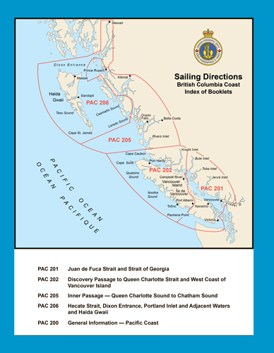
Detailed descriptions of geographical areas are given in a series of booklets. Their limits are printed on the back cover. The appropriate descriptive booklet(s) of Sailing Directions should be consulted in conjunction with this PAC 200 - General Information booklet.
Tide and current information revised by the Canadian Hydrographic Service.
Meteorological information supplied by the Atmospheric Environment Service, Environment Canada.
Photographs by the Canadian Hydrographic Service unless otherwise indicated.
Contents
Preface
Explanatory notes
Abbreviations
Chapter 1 General Information, Routes and Port Facilities
Canada
British Columbia
Transportation
Communications
Vessel Traffic Services (VTS)
Border Crossing
Security
Regulations
Routes
Pilotage
Port Facilities and Services
Chapter 2 Navigational Hazards
Seamounts
Hydrographic and Seismic Surveys
Firing Practice and Exercise Areas
Fishing Vessels
Aquaculture
Traffic
Cables and Pipelines
Bridges
Magnetic Anomalies
Natural Environment and Protected Areas
Search and Rescue
Cold Water Survival
Chapter 3 Aids to Navigation, Radio and Electronic Positioning
Aids to Navigation
Radio Aids to Navigation
Radar
Global Navigation Satellite Systems
Chapter 4 Nautical Publications
CHS Publications
Nautical Charts
CCG and Other Publications
chapter 5 Natural Conditions
Seabed
Meteorology
West Vancouver Island
Juan de Fuca Strait
Strait of Georgia
Johnstone Strait Region
Northern Shelf Region
Deep Sea Region
Water Density
Ice
Tide and Current Information
Tides
Surface Currents
Tidal Currents
Non-tidal Currents
Waves
Tsunami
Appendices Sail Plan
Distance Tables
Wind Tables
Frequency of Fog
Beaufort Scale of Wind Force
Federal and Provincial Powers for Protecting Marine Areas
Metric Conversion Table
Diagrams Area of Application of CanadaвАЩs Oceans Strategy
Main Shipping Routes to/from Alaska and Japan
Main Shipping Routes - BC South Coast
Main Shipping Routes - BC North Coast
Pilot Boarding Stations
Commercial Fishing Methods
Typical Aquaculture Site Layouts
Kelp
Life Expectancy in Water
Survival in Cold Water
Basic requirements for GPS signal generation
Examples of Obstruction Errors
Relation between tidal surfaces, charting datums and physical features
Source Classification Diagram
Sounding Methods
Five Easy Steps for Updating your Nautical Chart
Tidal Stream Information (TSI 1)
Tidal Stream Information (TSI 2)
Tidal Stream Information (TSI 3)
Stages of Tidal Streams
Distribution of Surface Currents of the North Pacific Ocean
General Circulation (Winter)
General Circulation (Spring)
General Circulation (Summer)
General Circulation (Autumn)
Non-tidal Surface Currents
Wave Statistics
Index


