CEN 307 Canadian Sailing Directions. North Channel of Lake Huron/Канадские лоции. Северный канал озера Гурон
Книга на английском языке
The First Edition of Sailing Directions, CEN 307 - North Channel of Lake Huron, 2000, has been compiled from Canadian Government and other information sources. In general, all hydrographic terms used in this booklet are in accordance with the meanings given in the Hydrographic Dictionary (Special Publication No. 32), published by the International Hydrographic Bureau.
This edition uses a new presentation of the description of the geographical areas.
General information for the Great Lakes is grouped within one booklet, Sailing Directions, CEN 300 - General Information, Great Lakes . It contains navigational information and a brief description of the main port facilities as well as geographic, oceanographic and atmospheric characteristics. Booklet CEN 300 also includes a geographical index for the Great Lakes area.
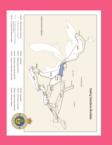
The geographical areas are described in a series of booklets; their limits are shown on the back cover of each booklet. For more information, consult the Catalogue of Nautical Charts and Publications, Great Lakes and St. Lawrence River.
Tidal, water level and current information has been revised by the Tides, Currents and Water Level Section of the Canadian Hydrographic Service.
The information quoted from the List of Lights, Buoys and Fog Signals in the Appendix is updated monthly by the Canadian Coast Guard and is available at the Fisheries and Oceans Canada web site: www.notmar.com.
The photographs by the Canadian Hydrographic Service, Fisheries and Oceans Canada.
Contents
Preface
Explanatory notes
Abbreviations
Chapter 1 North Channel - Eastern part
General
East entrance to North Channel
Heywood Island
Frazer Bay and McGregor Bay
Frazer Bay entrance
Frazer Bay and Baie Fine
McGregor Bay
Boat Passage and La Cloche Channel
Manitowaning and Sheguiandah Bays
Manitowaning Bay
Sheguiandah Bay
Heywood Island to Little Current
Heywood Island to McKenzie Island
Little Current - Eastern approaches
East entrance channel to Little Current
Little Current harbour
Little Current - Western approaches
Chapter 2 NE part and main central route
Genera
Waubuno Channel
Waubuno Channel to Whitefish Falls
Approaches to Bay of Islands
Bay of Islands
Whitefish River
Approaches to La Cloche Channel
La Cloche Channel to Whitefish Falls
Chapter 3 Main central route
General
Mackay’s Point to John Island
Mackay’s Point to Clapperton Island
Clapperton Island to Mississagi Island
South coast of Aird and John Islands
Chapter 4 Central part - South shore - West Bay to False Detour Channel
General
West Bay
Clapperton Channel
Clapperton Island to Blackstock Point
Blackstock Point to Meldrum Point
Bayfield Sound
Cape Roberts to Meldrum Bay
Meldrum Bay and approaches
Meldrum Point to False Detour Channel
Chapter 5 North shore - Waubuno Channel to Webber Island
General
Northern route to McBean Channel and Whalesback Channel
Waubuno Channel to McBean Channel
McBean Channel
Little Detroit and approaches
Whalesback Channel
Spanish River and approaches
Aird Bay and approaches
Spotted Island to Wicksteed Point
John Harbour and approaches
Whalesback Channel - Western approaches
Outlying features
Scott Passage and approaches
Turnbull Passage and approaches
South Passage and approaches
Serpent Harbour and approaches
Lally Point to Webber Island
Blind River and approaches
Comb Point to Webber Island
Chapter 6 West End - St. Joseph Channel and Lake George
General
Offshore islands and reefs
North Shore - Webber Island to Bruce Mines
Webber Island to Thessalon
Thessalon to Bruce Mines
South Shore - False Detour Channel to Gravel Point
Drummond Island
Potagannissing Bay
Fox Island to Gravel Point
St. Joseph Channel
Eastern approach to St. Joseph Channel
Canoe Point to Richards Landing
Richards Landing to Harwood Point
Harwood Point to Lake George
Lake George
Squirrel Island to Bell Point
Bell Point to Black Point
appendices Sail Plan
Table of Marina Facilities
List of Lights, Buoys and Fog Signals
Index


