CEN 306 Canadian Sailing Directions. Georgian Bay/Канадские лоции. Залив Джорджия
Книга на ангрийском языке
The Second Edition of Sailing Directions, CEN 306 - Georgian Bay, 2015, has been compiled from Canadian Government and other information sources. In general, all hydrographic terms used in this booklet are in accordance with the meanings given in the Hydrographic Dictionary (Special Publication No. 32), published by the International Hydrographic Organization.
This edition introduces a new chapter layout and Print-on-Demand technology.
General information for the Great Lakes is grouped in one booklet: Sailing Directions, CEN 300 - General Information, Great Lakes . It contains navigational information and a brief description of the main port facilities as well as geographic, oceanographic and atmospheric characteristics. Booklet CEN 300 also includes a geographical index for the Great Lakes.
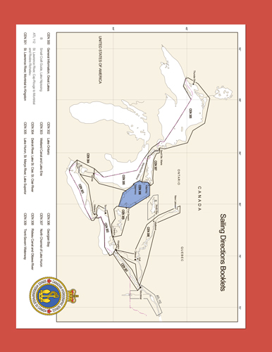
The detailed description of the geographical areas is given in a series of booklets. Their limits are printed on the back cover of the booklets. The appropriate descriptive booklet(s) should be consulted in conjunction with the CEN 300 - General Information, Great Lakes booklet.
Tidal, water level and current information has been revised by the Tides, Currents and Water Level Section of the Canadian Hydrographic Service.
The photographs are by the Canadian Hydrographic Service, Fisheries and Oceans Canada.
Contents
Preface
Explanatory notes
Abbreviations
Chapter 1 General Information
General
Chart datum and surveys
Aids to navigation
Cables
Hospitals
Marina information
Historical background
Charting Georgian Bay
Chapter 2 Entrance and northwest part
General
Entrance channels
Main Channel to Bears Rump Island
Yeo Channel to Wall Island
Fitzwilliam Channel
Owen Channel
Off-lying islands and shoals
Tamarack Point to Cape Smith (Manitoulin Island)
Cape Smith to North Channel
Offshore features
Cape Smith to Big Burnt Island
East Entrance to North Channel
Approaches to Indusmin quarries and Killarney Bay
Lansdowne Channel
Channels south of Cove Island
Devil Island Channel
Cape Hurd Channel to Tobermory
Tobermory
Tobermory to Cabot Head
Chapter 3 Southwest and west shores
General
Cabot Head to Cape Croker
Cape Croker to Cape Commodore
Wiarton
Cape Commodore to Cape Rich
Owen Sound
Cape Rich to Delphi Point
Meaford
Thornbury
Approaches to Collingwood
Collingwood
Collingwood to Gidley Point
Chapter 4 East shore - South part
General
Western Islands
Moose Deer Point to The Watchers
Approach to the small-craft route
Outer islands
Christian Island to Methodist Point
Hope Channel and Christian Channel
Methodist Point to Beausoleil Island
Approaches to the inshore small-craft route
Approaches to Penetang Harbour and Midland Bay
Approaches to the small-craft route
Penetang Harbour
Midland Bay
Midland
Tiffin
Midland Bay to Sturgeon Point
Hogg Bay
Port McNicoll
Victoria Harbour
Sturgeon Point to Waubaushene
Access route from Sturgeon Bay
Chapter 5 East shore - Central part
General
Moose Deer Point to Bateau Island
Waubuno Channel
Lone Rock to Bald Island
Small-craft routes
Waubuno Channel to South Channel
Bald Island to Iron Rock
Alternate route: Bald Island to Iron Rock
Iron Rock to Rose Island
Rose Island and adjacent channels
Bateau Island to McCoy Islands
Western Approach to Parry Sound
Main Channel to Parry Sound
Outer entrance
Inside channel - Red Rock to Twin Sisters Island
Red Rock to Carling Rock
Carling Rock to Killbear Point
Parry Sound (sound)
Killbear Point to Depot Harbour
Depot Harbour
Killbear Point to Salt Point
Approaches to Parry Sound Harbour
Parry Sound - North part
Killbear Point to Carling Bay
Carling Bay
Carling Bay to Parry Sound
North Entrance to Parry Sound Harbour
Parry Sound Harbour
Town of Parry Sound
Fryingpan Island to Turning Island
Southern approach to Turning Island
South Channel
Round Island to Flossie Island
Alternate routes
Flossie Island to Leisur Lee Point
Leisur Lee Point to Rose Point
Southwest Approach to Parry Sound
Turning Island to Iron Rock
Chapter 9 Inshore Route - Parry Sound to Byng Inlet General
Carling Rock to Twin Sisters Island
Alternate routes
Carling Rock to Snug Island.
SW access to Shebeshekong Channel
Snug Island to Galna Island
Galna Island to Twin Sisters Island
Twin Sisters Island to Bayfield Inlet
Twin Sisters Island to Turning Island
Turning Island to Pointe au Baril
Turning Island to Tonches Island
Pointe au Baril to Pointe au Baril Station
Pointe au Baril to Hangdog Reef
Offshore route - Nares Ledge to Hangdog Reef
Hangdog Reef to Bayfield Harbour
Bayfield Harbour
Bayfield Harbour to Byng Inlet
Bayfield Harbour to The Brothers
The Brothers to Gereaux Island
Chapter 10 Inshore Route - Byng Inlet to Killarney General
Byng Inlet to Key Harbour
Clark Island to Champlain Island
Champlain Island to Key Harbour
Offshore approach to Key Harbour
Key Harbour and Key River
Key Harbour to French River
Bigsby Island to Northeast Passage
Northeast Passage
Bustard Islands
Alternate route - The Shirt Tails to Lefroy Island
French River
Main Outlet (French River)
French River to Beaverstone Bay
SW approach to French River
Bustard Rocks to Rooster Reef
Approaches to Beaverstone Bay
Beaverstone Bay to Killarney
Beaverstone Bay
East part of Collins Inlet
West part of Collins Inlet
Western entrance to Collins Inlet
Killarney
Killarney Channel west entrance
Killarney Bay
appendices Sail Plan
Table of Marina Facilities
Index


