CEN 305 Canadian Sailing Directions. Lake Huron, St. Marys River, Lake Superior/Канадские лоции. Озеро Гурон, река Сент-Мэрис, озеро Верхнее
Книга на английском языке
The First Edition of Sailing Directions, CEN 305 - Lake Huron, St. Marys River, Lake Superior, 2000, has been compiled from Canadian Government and other information sources.
In general, all hydrographic terms used in this booklet are in accordance with the meanings given in the Hydrographic Dictionary (Special Publication No. 32), published by the International Hydrographic Bureau.
This edition uses a new presentation of the description of the geographical areas.
General information for the Great Lakes is grouped in one booklet: Sailing Directions, CEN 300 - General Information, Great Lakes . It contains navigational information and a brief description of the main port facilities as well as geographic, oceanographic and atmospheric characteristics. Booklet CEN 300 also includes a geographical index for the Great Lakes area.
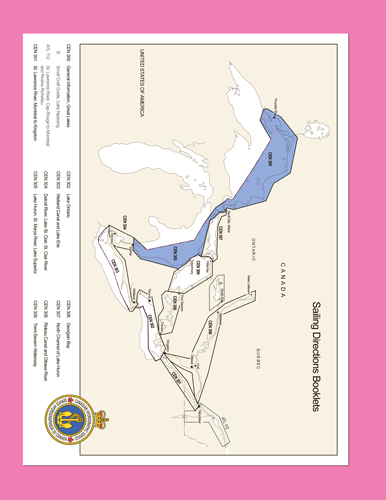
The geographical areas are described in a series of booklets; their limits are shown on the back cover of each booklet. For more information, consult the Catalogue of Nautical Charts and Publications, Great Lakes and St. Lawrence River.
Tidal, water level and current information has been revised by the Tides, Currents and Water Level Section of the Canadian Hydrographic Service.
The information quoted from the List of Lights, Buoys and Fog Signals in the Appendix is updated monthly by the Canadian Coast Guard and is available at the Fisheries and Oceans Canada web site: www.notmar.com.
The photographs are by the Canadian Hydrographic Service, Fisheries and Oceans Canada.
Contents
Preface
Explanatory notes
Abbreviations
Chapter 1 Lake Huron - East shore
General
Northern approaches to St. Clair River
Point Edward
Point Edward to Goderich
Port Franks
Grand Bend
Bayfield
Goderich
Goderich to Fishing Islands
Kincardine
Port Elgin
Approaches to Southampton
Southampton
Sauble River
Fishing Islands
Approaches to Oliphant
Oliphant to Red Bay and Pike Bay
Approach channels
Fishing Islands to Cape Hurd
Stokes Bay
Stokes Bay to Cape Hurd
Chapter 2 Lake Huron - North Shore
General
Entrance channels
Manitoulin Island
Hungerford Point to Providence Bay
South Bay
South Baymouth to Providence Bay
Providence Bay to Duck Islands
Duck Islands
Duck Islands to Mississagi Strait
Mississagi Strait
South Shore of Cockburn Island
False Detour Channel
East side of channel
South Shore of Drummond Island
Chapter 3 St. Marys River
General
St. Marys River Vessel Traffic Service
De Tour Passage
Munuscong Lake to Lake Nicolet
St. Marys Falls
Sault Ste. Marie (Canada) Canal
Sault Ste. Marie
St. Marys Falls to Gros Cap Reefs
Birch Point to Whitefish Bay
Chapter 4 Lake Superior - East Shore
General
Approaches to St. Marys River from NW
South and west sides of Whitefish Bay
East side of Whitefish Bay
Coppermine Point to Montreal River
Montreal River to Cape Gargantua
Cape Gargantua to Michipicoten Bay
Michipicoten Bay
Chapter 5 Lake Superior - NE Shore
General
Offshore dangers
Superior Shoal
Michipicoten Bay to Pilot Harbour
Michipicoten Island, North Side
Caribou Island
Off-lying banks
Michipicoten Island, South Side
Approaches to Quebec Harbour
Quebec Harbour
Pilot Harbour to Otter Island
Otter Island to Peninsula Harbour
Approaches to Peninsula Harbour
Peninsula Harbour to Bottle Point
Chapter 6 Lake Superior - Nipigon Bay and Approaches General
Slate Islands
Bottle Point to Schreiber Point
Approaches to Nipigon Bay
South Sides of St. Ignace and Fluor Islands
Channels to Nipigon Bay
Schreiber Channel to Rossport
Routes north of Channel Island
Simpson Channel
Nipigon Bay
Crow Point to Vert Island
Vert Island to Nipigon River
Nipigon Strait to Nipigon River
Chapter 7 Lake Superior - Black Bay and Approaches - Thunder Bay
General
Nipigon Strait to Black Bay
Approaches to Black Bay
Black Bay
Approaches to Thunder Bay
Isle Royale
Passage Island to Port of Thunder Bay
Passage Island to Thunder Cape
Thunder Bay - East Entrance
Pigeon Bay to Port of Thunder Bay
Off-lying islands and shoals
Victoria Island to Port of Thunder Bay
Approaches to Port of Thunder Bay
Port of Thunder Bay
Southern part of Port of Thunder Bay
Facilities in Thunder Bay
North and east shores of Thunder Bay
appendices Sailing Plan
Table of Marine Facilities
List of Lights, Buoys and Fog Signals
Index


