CEN 303 Canadian Sailing Directions. Welland Canal and Lake Erie/Канадские лоции. Канал Велланд и озеро Эри
Книга на английском языке
The First Edition of Sailing Directions, CEN 303 - Welland Canal and Lake Erie, 1996, has been compiled from Canadian Government and other information sources. In general, all hydrographic terms used in this booklet are in accordance with the meanings given in the Hydrographic Dictionary (Special Publication No. 32), published by the International Hydrographic Bureau.
This edition introduces a new presentation and layout of the geographical areas.
General information for the Great Lakes is grouped in one booklet: Sailing Directions, CEN 300 - General Information, Great Lakes. It contains navigational information and a brief description of the main port facilities as well as geographic, oceanographic and atmospheric characteristics. A geographical index at the end of that booklet should also be consulted.
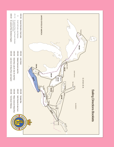
The detailed descriptions of the geographical areas is given in a series of volumes and booklets. Their limits are printed on the back cover of the booklets. The appropriate descriptive booklet(s) should be consulted in conjunction with CEN 300 - General Information, Great Lakes booklet.
Tidal, water level and current information has been revised by the Tides, Currents and Water Level Section of the Canadian Hydrographic Service.
Meteorological and ice information has been revised by the Atmospheric Environment Service, Department of the Environment.
The photographs are by the Canadian Hydrographic Service, Fisheries and Oceans Canada.
Contents
Preface
Explanatory notes
Abbreviations
Chapter 1 Welland Canal
General
Port Weller Harbour
Welland Canal
Port Colborne
Chapter 2 Upper Niagara River and Buffalo Harbor
General
Upper Niagara River
Niagara River - Old channel
U.S. shores - Upper Niagara River and Buffalo Harbor
Chapter 3 Lake Erie - Niagara River to Long Point
General
Niagara River to Port Colborne
Port Colborne to Port Maitland
Port Maitland
Port Maitland to Long Point Bay
Long Point Bay
Nanticoke Harbour. Nanticoke Creek. Port Dover. Port Dover to Deep Hole Point. Inner Bay
Chapter 4 Lake Erie - Long Point to Point Pelee General
Long Point to Port Burwell
NE and south sides of Long Point. Port Burwell
Port Burwell to Port Stanley
Port Stanley
Port Stanley to Rondeau Bay
Rondeau Bay
Rondeau Bay to Point Pelee
Wheatley
Chapter 5 Lake Erie - Point Pelee to Detroit River
General
Pelee Passage
Pelee Island
Islands and dangers WNW of Pelee Island
Point Pelee to Detroit River
Leamington. Kingsville
Appendices Sail Plan
Distance Table
Index


